Somewhere between the thirty and forty mile mark I began wondering why I had let my daughter Sara talk me into this trip. Sara had been pestering me all summer to bicycle the Natchez Trace Parkway with her but I wasn’t sure my aging body would make it so I kept coming up with lame excuses. Her persistence finally wore me down but only after a couple of major concessions on her part.
First, no way was I going to tackle the entire 450-mile length of the Nashville, TN to Natchez, MS parkway. Second, no camping. If I was going to bike during the day I was going to sleep in luxury at night. So after much negotiation, we decided that the section of the Trace from Tupelo, MS to Columbia, TN, a distance of 130 miles, was about right. Our plan was to leisurely pedal this section in three days, stopping along the way to take in the numerous natural and historical sites and spending the nights in bed and breakfasts. A last minute change of plans cut our trip down to 84 miles, three nights and two days of biking--still an ambitious trip as far as I was concerned. No hundred mile days for me.
Our trip started when we checked into the Mockingbird Inn near downtown Tupelo. Our host Sharon Robertson showed us to the Sanibel Island room of the extremely cool (according to Sara) two-story house. I had to agree with her, it was very cool. Each room has a different theme, from Africa to Paris to Venice. Our room’s island theme was about as close to the atmosphere of a beach house as you’ll get in Tupelo. Maybe this trip wasn’t going to be so bad after all.
We relaxed on a backyard swing beneath huge overhanging shade trees and met Rod and Betsy Chamberlain from Georgia. They were also biking the Trace, Rod attempting the leg from Tupelo to Franklin, with Betsy driving the support vehicle and joining him for selected stretches. Over dinner at a pub just across the street, I found out that Rod is 76 years old, so I figured maybe I could make it after all. Little did I know--more to come on that.
We were up early the next morning enjoying the Mockingbird’s bountiful breakfast. This inn has been named one of the top ten B&Bs in Mississippi and, based on our experience there, the rating is in no danger of slipping.
I almost hated to leave but we bid good-bye to Rod and Betsy and headed out to the Natchez Trace. If you’ve never ridden the Trace, it is a completely different experience from driving it. Traffic is sparse and no commercial trucks are allowed, so you can enjoy a serene ride without having to worry about ending up as road kill. The parkway has gently rolling hills and gracefully contoured curves and the scenery is a snaking ribbon of imposing trees, cotton fields, winding creeks and lazy-flowing rivers. Clear springs, towering overlooks, Confederate graves, caves, Indian burial mounds, and historical markers--including the grave of explorer Meriwether Lewis--appeared at frequent intervals. This gave me lots of excuses to stop and rest. We quickly settled into a slow, idyllic pace and pedaled to our own rhythms.
Our first day’s goal was to bike 45 miles to the Belmont Hotel in Belmont, MS. I still swear that Mississippi miles are longer. This was where I began wondering if I would make it. Our normal 12-mile-an-hour pace slipped to six (an average we never exceeded the entire trip). We struggled into the lobby of the grandly restored Belmont Hotel hot and tired. The Belmont was built in 1924 and stepping through the double front doors immediately transports you back to that decade. The lobby and dining room still feel elegant. Unfortunately, the period feel was lost on us. The only thing we wanted to see was dinner and a bed.
I did not have the same enthusiasm when I awoke the second morning. More like trepidation. Would I make it through the day or end up sprawled by the roadside, desiccated and distraught? Ron Deaton, the owner of the Belmont, must have sensed my misgivings. He loaded our bikes on a trailer and gave us a lift back to the parkway, avoiding seven miles of traffic on busy Highway 25. Once we were back on our bikes we felt better and--lo and behold--we soon heard someone huffing up a long hill behind us. It was Rod who had camped at nearby Tishomingo State Park. We rode with him for a while but we could see we were slowing him down so urged him to go ahead. Last we saw of him was his bike disappearing on the horizon. So much for my hope of three decades of youth giving me an advantage.
Surprisingly, the second day was much easier. We covered 40 miles easily, stopping along the way at Freedom Hills Overlook; at 800 feet, the highest Alabama point on the parkway; Colbert Ferry on the banks of the Tennessee River; and Rock Springs where dozens of hummingbirds were congregating before their annual migration. We pulled into Florence and the Wood Avenue Inn for our last night. This 1889 Victorian mansion has all the trappings--wide porches, octagonal towers, antiques, and fireplaces everywhere. We sat on the shaded back porch and celebrated our successful trip.
Footnote: Rod Chamberlain emailed us and he made it all the way to Franklin. If he can do it, I guess there is still hope for me. Maybe I’ll talk Sara into riding that section next year.
If you would like to bike the Trace check out the Natchez Trace Bed and Breakfast Reservation Service which can assist in arranging biking trips. Many of the B&Bs are close to the Trace or will provide shuttles to and from the parkway. 1-800-377-2770 or www.bbonline.com/natcheztrace
We found the B&B owners to be extremely “biker friendly”, providing bike shuttles, tips on backroads to avoid traffic, where to get water, and directions to restaurants within walking distance. We recommend the three we stayed at for this reason.
The Mockingbird Inn, 305 North Gloster Street, Tupelo, MS 38803, 601-841-0286. Within walking distance of restaurants. Two easy biking miles from the Trace. One of the best bed and breakfasts we have ever experienced.
The Belmont Hotel, 121 Main Street, Belmont, MS 38827, 662-454-7948. Eight miles from the Trace. One restaurant within walking distance. Check with owner Ron Deaton for shuttle back to the Trace.
Wood Avenue Inn, 658 North Wood Avenue, Florence, AL 35630, 205-766-8441. Twelve miles from the Trace but the owners will provide shuttle to and from the parkway. Within walking distance of many restaurants.
(A version of this article originally appeared in the Nashville Tennessean.)
“Not all those who wander are lost.” – J. R. R. Tolkien
"Everybody dies. Not everybody really lives."
The saddest sound in the world is a man saying, "I wish I'd have done that."
Monday, February 28, 2011
Tuesday, January 4, 2011
Iceland: Bad Name, Great Country
The charisma level is low; even the name sounds bleak: Iceland? Conjures up visions of cold days, colder nights, frostbitten toes and somber skies. Because of its gloomy image the country doesn’t make many appearances on peoples’ bucket lists. So I was not enthused about visiting but it was my buddy Ed’s turn to pick the destination for our latest adventure trip and Iceland it was. My hesitancy was not eased on our approach to Keflavik airport. The ground below looked stark and barren, devoid of any distinguishing features and, especially, any vegetation. Oh boy, this is gonna suck.
That’s a question I keep asking myself over the next days as we make our way around the island. The Icelandic backcountry’s natural beauty is so unexpected that we find ourselves constantly in awe. Iceland’s volcanoes and geysers and glaciers and waterfalls challenge the writer’s storehouse of adjectives; illusory, otherworldly, fantastic—nothing seems to capture the feel of the country. Everything lies outside the parameters of normality. It’s a raw and powerful beauty, the country throws rugged vistas at you, daring you not to be captivated by the show.
We trekked around the island’s perimeter, roughly following the Ring Road, a two-lane, 900 kilometer pavement-and-gravel-roadway that bumps against the North Atlantic as it circumscribes the coast. Along the way we had a full schedule of whitewater rafting, hiking, glacier climbing, whale watching and snowmobiling .
We modified our plans somewhat to vent our anger at the erupting Eyjafjallajökull volcano, whose shifting ash plume had delayed our arrival from JFK, costing us a day of partying in Reykjavik. Wanting to get an up close look at the active cauldron, we drove up a narrow back road on the volcano’s north face followed by a short hike to a dead end on the banks of a raging mountain river. A low cloud cover hid the peak but we could hear an ominous low rumbling—an extended thunderous roll—booming out of the gloomy clouds. The water was swift and milky from the volcano ash and blocked our progress—no way we would see the volcano from this approach. Disappointed, we backtracked to the Ring Road and a couple of hours later rounded a curve and there it was—a massive gray plume reaching 20,000 feet into the sky, pumping tons of ash, rocks and fire into the clear blue sky. It was impressive—a powerful display of nature at is angriest. A massive field of steaming rock flow fingered down the mountainside, threatening the postcard-pretty house and barns of a hapless farmer caught in its path.
The effects of the volcano were still obvious the next day as we hiked up the face of Skaftafell glacier. The crusty white ice was sprinkled with a fine dusting of gray ash, marring its natural beauty at the lower levels. As we climbed further the ash seemed to dissipate and the characteristic glacial blue hue revealed itself. We hiked through ice tunnels and crevasses and blue ice caves, an easy trek on one of Iceland’s many disappearing glaciers. Our guide pointed across a low bouldered plain, stretching some 800 meters to the ocean. The glacier had retreated that distance in little over ten years, a sad tale repeated all over the country.
Near Hofn we impulsively took an unmarked side road into the interior and hiked up into the mountains where we stumbled into the midst of a herd of reindeer. They approached within ten meters as we crouched behind a low knoll, the herd’s large bull silhouetted against the steel gray sky as he sniffed the air sensing our presence. It was one of those once-in-a-lifetime poses and we were just in the right place to capture it.
At Husavik on the northern part of the island we cruised out of the harbor to catch glimpses of minke and humpback whales which obligingly surfaced and showed their tails for us as we snapped pictures. It was nature at its finest, their black smooth skin slipping slowly and dramatically into the blue waters of the bay. So it was particularly jarring and upsetting to see minke whale on the menu of the restaurant that night--an unsettling and brutal aspect to an otherwise enlightened country.
After an easy day on the ocean, we were ready for some more strenuous action and so we were mildly disappointed with the whitewater on the Vestari Jokulsa, one of Icleand’s premier rafting rivers. This is primarily a Class II-III river. Ed and I have rafted all over the world and while the scenery was excellent, the action was low. Our guide, Jeff, sensed our frustration and told us we needed to return the next day and do the Austari Jokulsa, one of the best whitewater rivers in the world. A good idea, we took him up on it, with plans to return in the morning. Unfortunately, his second recommendation was not so good. We were staying the night in the tiny village of Holar, a wide spot in the road consisting of a few farmhouses and a University. Jeff told us to be sure to check out the Beer Club, run by a friend of his at the University.
Big mistake. The club is open to faculty, staff and guests only. Since we were staying in a cabin on campus, we qualified as guests. Our bartender, who insisted his name was Gummi Bear, plied us with multiple samples of every brand of beer sold in Iceland, the faculty members joined us in revelry and we staggered back to our cabin in the early morning light. Not a good prep for a day of whitewater.
But our raft awaited and the next morning we pulled on our dry suits (the Jokulsa is glacier fed and COLD) and warily stepped into the river. The Austari Jokulsa lived up to its billing. It is an awesome river with big water, second only to the Colorado through the Grand Canyon in my experience. Huge standing waves provided two plus hours of continuous and intimidating rapids, carving through some of the most rugged and forbidding landscape in Iceland. The paddle was challenging and exhausting and after a full day of rapids, eddies and drops we were exhausted.
We had just enough energy to drive into Reykjavik and grab a couple hours of sleep before hitting the legendary nightlife of the city. Reykjavik rocks all night long. A string of bars in city center is a hive of activity that spins up near midnight and parties on until early morning. Don’t like the scene? Move to the bar next door, there is another party rocking through the night. Reykjavik’s party crowd is young, cool and intent on having fun.
Reykjavik is cosmopolitan and modern with remnants of its origins as a shipping port still evident, a charming, clean and picturesque city with an easy going, vibrant populace. Another surprise, it hums with the energy of a major European city. Just another in a long string of surprises from this country.
Details: We set up our trip through Nordic Visitor, who took care of all guides and arrangements based on our trip desires.
http://www.nordicvisitor.com/
Laugavegur 26
101 Reykjavik, Iceland
Tel: +354 578 20 80
Direct: +354 578 20 86
Sunday, January 2, 2011
Deal's Gap, The Southeast's Premier Biking Road
It took a five hour ride, an overnight camp in the rain and a cold morning before we finally arrived at our destination: a twisting, snaking, up and down stretch of two-lane road that has become a Mecca for motorcycle riders throughout the Southeast. This desolate ribbon of narrow asphalt in the Smoky Mountains of North Carolina attracts motorcyclists from all over the country who revel in the road’s challenging banked curves and blind turns.
This is Deal’s Gap, a name that triggers almost mystical feelings in motorcyclists. It is located high in the mountains on US Highway 129 between Topton, North Carolina and Maryville, Tennessee and straddles the state line. Highway 129 curls and bends for more than fifty miles and is a challenging ride the whole way, but in one eleven mile stretch the road twists itself into a spaghetti bowl of 318 turns, a continuous feast of rights, lefts, climbs, and drops. There is hardly a better motorcycle road anywhere in the country. The Gap is legendary within biking circles and on weekends the road is headlight-to-tailpipe with hundreds of bikes.
Deal’s Gap is both demanding and beautiful, carving its way through the Smoky’s lush mountain forests and past breathtaking vistas of deep valleys, clear mountain lakes, and forested mountains. But most riders barely notice the beauty surrounding them, hardly daring to tear their eyes from the highway lest they become road kill. This is not a road for the faint-hearted.
The Gap’s reputation is what brought the five of us across three states to attack its legendary curves. But now that we’re here at the bottom of the hill and ready to go, we have a couple of problems. For one thing, the day has turned cold and rainy and there is a fine mist swirling around us. To make matters worse, the rain from the previous night has pounded many of the leaves out of the trees and onto the road. Slick curvy roads covered with wet leaves are a bad combination for motorcycle riding.
So we adjourn to Deal’s Gap Motorcycle Resort, a combination gas station, store and general meeting place for Gap riders to talk things over. The store is a small dimly lit place stocked with T-shirts, hats and other Deal’s Gap memorabilia with sayings like “Asphalt Surfer”, “I Survived Deal’s Gap”, and other less-than-confidence-inspiring slogans. We gather around a television playing a continuous video of two riders leaning and gunning their way through the Gap. The view on the screen is from the handlebars of the tailing bike and we watch the lead bike lean, slide, and squirt through S-curves, around bends and across double yellow lines, passing slower moving bikes and cars at dangerous (and obviously illegal) speeds. The speedometer of the trailing bike is visible in the video frame and it registers speeds that we usually don’t see on the Interstate. Watching the video is not a good idea, kind of like seeing Jaws before going for a swim in the ocean. It causes a lot of shifting of feet and “Maybe we oughta wait a while” discussions. But we are five guys astride motorcycles--no way any one of us is going to suggest turning back. Manhood is at stake.
So we mount up and head into the Gap. With 318 curves, everything happens too fast to catalogue in your brain but here’s what I remember of the ride:
The road twists uphill to the mountain’s crest, crosses the Tennessee state line, and then begins a dizzying downward spiral. Dark gray cliffs hug the road on one side and the skinny shoulder drops hundreds of feet into nothingness on the other. Stands of unforgiving oak, hickory and maple trees crowd right up to the road’s edge. As I come around a sweeping left curve, there is a tow truck parked on a pull off, like a vulture waiting for dinner. Around another curve I come upon a Tennessee state trooper car, blue light flashing, hovering near a wrecked bike.
I had dreamed about downshifting and upshifting, leaning, accelerating and decelerating up and down the rapid elevation changes of the road. Instead all I see are dark spots on the road that look ominously like ice and blankets of slippery leaves sprinkled liberally in the middle of 180-degree turns. I glance down at my speedometer: barely 35 miles per hour. So much for my plans to swoop through the Gap and arouse the envy of my friends.
I’ve just about resigned myself to an excruciatingly slow run through the Gap when the road almost miraculously dries out and we crank up the speed. John, the only Deal’s Gap veteran in our group, is ahead of me on his black Honda Shadow, leaning through the curves. I try to keep up, not an easy task. But I get into a rhythm, leaning easily from left to right, shifting my weight and feeling the exhilaration of dancing through the curves. Too soon, we come out of the last sweeping curve, pumped with excitement.
At the bottom of the hill we pull over and the rest of our group join us. We all come through unscathed, even one friend, who—unbelievably—has not ridden for twenty years and borrowed a motorcycle for this trip. I figured he would eat pavement at Deal’s Gap but he, like the rest of us, is an immediate Gap fan and we begin planning a return trip before our engines even have time to cool. What can I say; it's an addiction.
(A version of this article originally appeared in the Huntsville Times)
This is Deal’s Gap, a name that triggers almost mystical feelings in motorcyclists. It is located high in the mountains on US Highway 129 between Topton, North Carolina and Maryville, Tennessee and straddles the state line. Highway 129 curls and bends for more than fifty miles and is a challenging ride the whole way, but in one eleven mile stretch the road twists itself into a spaghetti bowl of 318 turns, a continuous feast of rights, lefts, climbs, and drops. There is hardly a better motorcycle road anywhere in the country. The Gap is legendary within biking circles and on weekends the road is headlight-to-tailpipe with hundreds of bikes.
Deal’s Gap is both demanding and beautiful, carving its way through the Smoky’s lush mountain forests and past breathtaking vistas of deep valleys, clear mountain lakes, and forested mountains. But most riders barely notice the beauty surrounding them, hardly daring to tear their eyes from the highway lest they become road kill. This is not a road for the faint-hearted.
The Gap’s reputation is what brought the five of us across three states to attack its legendary curves. But now that we’re here at the bottom of the hill and ready to go, we have a couple of problems. For one thing, the day has turned cold and rainy and there is a fine mist swirling around us. To make matters worse, the rain from the previous night has pounded many of the leaves out of the trees and onto the road. Slick curvy roads covered with wet leaves are a bad combination for motorcycle riding.
So we adjourn to Deal’s Gap Motorcycle Resort, a combination gas station, store and general meeting place for Gap riders to talk things over. The store is a small dimly lit place stocked with T-shirts, hats and other Deal’s Gap memorabilia with sayings like “Asphalt Surfer”, “I Survived Deal’s Gap”, and other less-than-confidence-inspiring slogans. We gather around a television playing a continuous video of two riders leaning and gunning their way through the Gap. The view on the screen is from the handlebars of the tailing bike and we watch the lead bike lean, slide, and squirt through S-curves, around bends and across double yellow lines, passing slower moving bikes and cars at dangerous (and obviously illegal) speeds. The speedometer of the trailing bike is visible in the video frame and it registers speeds that we usually don’t see on the Interstate. Watching the video is not a good idea, kind of like seeing Jaws before going for a swim in the ocean. It causes a lot of shifting of feet and “Maybe we oughta wait a while” discussions. But we are five guys astride motorcycles--no way any one of us is going to suggest turning back. Manhood is at stake.
So we mount up and head into the Gap. With 318 curves, everything happens too fast to catalogue in your brain but here’s what I remember of the ride:
The road twists uphill to the mountain’s crest, crosses the Tennessee state line, and then begins a dizzying downward spiral. Dark gray cliffs hug the road on one side and the skinny shoulder drops hundreds of feet into nothingness on the other. Stands of unforgiving oak, hickory and maple trees crowd right up to the road’s edge. As I come around a sweeping left curve, there is a tow truck parked on a pull off, like a vulture waiting for dinner. Around another curve I come upon a Tennessee state trooper car, blue light flashing, hovering near a wrecked bike.
I had dreamed about downshifting and upshifting, leaning, accelerating and decelerating up and down the rapid elevation changes of the road. Instead all I see are dark spots on the road that look ominously like ice and blankets of slippery leaves sprinkled liberally in the middle of 180-degree turns. I glance down at my speedometer: barely 35 miles per hour. So much for my plans to swoop through the Gap and arouse the envy of my friends.
I’ve just about resigned myself to an excruciatingly slow run through the Gap when the road almost miraculously dries out and we crank up the speed. John, the only Deal’s Gap veteran in our group, is ahead of me on his black Honda Shadow, leaning through the curves. I try to keep up, not an easy task. But I get into a rhythm, leaning easily from left to right, shifting my weight and feeling the exhilaration of dancing through the curves. Too soon, we come out of the last sweeping curve, pumped with excitement.
At the bottom of the hill we pull over and the rest of our group join us. We all come through unscathed, even one friend, who—unbelievably—has not ridden for twenty years and borrowed a motorcycle for this trip. I figured he would eat pavement at Deal’s Gap but he, like the rest of us, is an immediate Gap fan and we begin planning a return trip before our engines even have time to cool. What can I say; it's an addiction.
(A version of this article originally appeared in the Huntsville Times)
Llama Luxury: Trekking the Backcountry in Comfort
Less than a mile into our hike through the thickly forested mountains of North Carolina I begin to appreciate my new hiking companion. He carries all my gear, does not bore me with endless conversation and follows silently behind me, keeping a discreet distance, stopping when I stop, trotting alongside when I scramble up a slope.
A couple of hours later we stop for lunch on a level plateau surrounded by a green palette of maple and oak trees. While I contentedly chew on my lunch, he just as contentedly chews on daisy asters and clover.
But what do you expect from a llama? My surefooted companion has freed me to enjoy the wildlife and scenery of the mountains without the burden of a cumbersome backpack full of food and gear. After years of lugging tents, sleeping bags, cooking utensils, clothes, food, and all the other paraphernalia that I seem to need to make it through a few days in the wilderness, I started thinking that there must be a better way. My answer came when I discovered llama trekking.
A popular activity in the Rockies, llama trekking is slowly catching on in the Smoky Mountains. And for good reason. Llamas are appealing creatures with personalities more like a dog than a horse and the freedom that comes with having a pack animal to carry your gear cannot be overstated.
If you’re like me, you don’t happen to have a llama standing around in your backyard so you’ll need to hook up with a llama trekking outfitter. There are at least two such companies in the Smokies and they offer a variety of treks, ranging from easy half-day adventures to extended three-day camping trips. I picked a company located near the eastern border of Great Smoky Mountains National Park in North Carolina.
Our overnight trek starts with a human-llama bonding session, kind of like one of those high school dances where you circle the crowd trying to pick up a hapless victim. I sidle up to a white and brown llama and he tilts his head sideways to have his ear scratched. That’s all it takes, I’m his new best friend. High school should have been this easy.
Bonding achieved, I load my stuff into my llama’s two saddlebags and we head into the mountains. I feel like Noah leading his charges to higher ground. The narrow mountain trail parallels one of those ubiquitous North Carolina mountain streams, tumbling cold and clear out of the highlands. As we traipse uphill through a lush thicket of mountain laurel I realize that this is going to be a typical Smoky Mountain hike—in a word, steep.
I also immediately grasp that I have entered a whole other level of backcountry trekking. The hiking, minus a thirty pound backpack, is liberating and the usual Spartan rules of lightweight and low volume packing are out the window; with a llama to bear the burden you can add a little extravagance to your trip--maybe a bottle of wine, a book, a pillow, an inflatable mattress. I could grow to love this llama thing.
That’s the bottom line; llama trekking adds a considerable degree of luxury to the usual freeze dried noodles, instant coffee, one set of clothes hiking trip. Goodbye austerity, hello comfort. But don’t get the idea that llama trekking is just for the out-of-shape and families with little kids. If you’re worried about the wimp factor, you can opt for long distance multi-day trips that offer more adventure.
No matter what your preference, llama trekking is a fun and unique adventure. Just don’t expect any campfire conversation from your new companion.
(A version of this article originally appeared in Blue Ridge Country)
A couple of hours later we stop for lunch on a level plateau surrounded by a green palette of maple and oak trees. While I contentedly chew on my lunch, he just as contentedly chews on daisy asters and clover.
But what do you expect from a llama? My surefooted companion has freed me to enjoy the wildlife and scenery of the mountains without the burden of a cumbersome backpack full of food and gear. After years of lugging tents, sleeping bags, cooking utensils, clothes, food, and all the other paraphernalia that I seem to need to make it through a few days in the wilderness, I started thinking that there must be a better way. My answer came when I discovered llama trekking.
A popular activity in the Rockies, llama trekking is slowly catching on in the Smoky Mountains. And for good reason. Llamas are appealing creatures with personalities more like a dog than a horse and the freedom that comes with having a pack animal to carry your gear cannot be overstated.
If you’re like me, you don’t happen to have a llama standing around in your backyard so you’ll need to hook up with a llama trekking outfitter. There are at least two such companies in the Smokies and they offer a variety of treks, ranging from easy half-day adventures to extended three-day camping trips. I picked a company located near the eastern border of Great Smoky Mountains National Park in North Carolina.
Our overnight trek starts with a human-llama bonding session, kind of like one of those high school dances where you circle the crowd trying to pick up a hapless victim. I sidle up to a white and brown llama and he tilts his head sideways to have his ear scratched. That’s all it takes, I’m his new best friend. High school should have been this easy.
Bonding achieved, I load my stuff into my llama’s two saddlebags and we head into the mountains. I feel like Noah leading his charges to higher ground. The narrow mountain trail parallels one of those ubiquitous North Carolina mountain streams, tumbling cold and clear out of the highlands. As we traipse uphill through a lush thicket of mountain laurel I realize that this is going to be a typical Smoky Mountain hike—in a word, steep.
I also immediately grasp that I have entered a whole other level of backcountry trekking. The hiking, minus a thirty pound backpack, is liberating and the usual Spartan rules of lightweight and low volume packing are out the window; with a llama to bear the burden you can add a little extravagance to your trip--maybe a bottle of wine, a book, a pillow, an inflatable mattress. I could grow to love this llama thing.
That’s the bottom line; llama trekking adds a considerable degree of luxury to the usual freeze dried noodles, instant coffee, one set of clothes hiking trip. Goodbye austerity, hello comfort. But don’t get the idea that llama trekking is just for the out-of-shape and families with little kids. If you’re worried about the wimp factor, you can opt for long distance multi-day trips that offer more adventure.
No matter what your preference, llama trekking is a fun and unique adventure. Just don’t expect any campfire conversation from your new companion.
Details: Two companies that offer llama trekking in the Smoky Mountains are English Mountain Llama Treks (828-622-9686, www.hikinginthesmokies.com) located near Hot Springs , NC and Smoky Mountain Llama Treks (865-428-6042, www.smokymountainllamatreks.com) near Sevierville , TN.
(A version of this article originally appeared in Blue Ridge Country)
Soaring Over Alabama
This is not right. I have a death grip on the control stick between my legs, the ground below is rushing towards me and there is no engine sound coming from my plane. In normal circumstances these factors would be a recipe for disaster.
From the back seat I hear a calm voice say “Pull back on the stick.” I ease the stick back and the sailplane gently climbs into the clear blue sky. Wow! What a rush! This is my first time to ever pilot any kind of aircraft and the glider plane’s almost instantaneous response to my touch on the stick is thrilling.
I’m soaring 8000 feet over the green foothills of the Appalachians in north Alabama and loving every minute of it. I swivel my head left and right and take in the expanse of forests, fields and undulating hills stretching for miles in both directions. The sunny sky is clear, a few puffy clouds cast faint shadows on the hills below. Off to the right I see the airplane which just towed us into the sky banking down to return to Moontown Airport, a tiny grass airstrip just east of Huntsville. That plane, a Piper Pawnee, is a muscular ex-cropduster that easily towed this light Blanik sailplane up to 6000 feet before I pulled the lever and released the tow cable.
The takeoff was stressful. Although my instructor, Mike Baker, had given me extensive basic flight instruction and orientation on the glider plane, the fact remains that I am a total novice as a pilot and jockeying the plane around while being towed by the Pawnee required all my concentration and a deft touch on the stick. By the time we reached 6000 feet I was already sweating profusely. And it took a supreme leap of faith to release that cable. No matter how much confidence I have in Mike and this glider plane, it was still scary to let go of the only thing with power and trust your life to the vagaries of invisible air currents and updrafts. But once I pulled the lever and released the cable, everything changed. The first couple of seconds were tense as I held my breath hoping the sailplane would not plummet nose first into the red Alabama dirt below but the plane shuddered a little in the Pawnee’s turbulence and then—magically—regained its composure and we were suddenly free and gracefully sweeping through the sky, silently soaring in the rising air.Now I’m scribing graceful arcs through the sky, banking the Blanik to one side and the other, gently swooping back and forth, a fluid ballet. The plane responds to my touch and I’m feeling pretty good about my piloting abilities. Mike tells me to put the plane into a shallow climb until I feel it start to stall, then push hard on the stick. I point the nose upward, wait for the telltale flutter of the stall and push the stick forward. The plane noses over and gathers speed in a smooth noiseless rush. I’m feeling comfortable, I expected this to be a high adrenalin adventure but the only way I can describe it is calming--no irritating engine drone, no scanning of oil pressure or engine temperature or RPMs. The controls in the Blanik are simple; a stick, control pedals, an air speed indicator, a string attached just ahead of the canopy to indicate wind direction, and a fore-and-aft ballast adjuster. That’s about it, just pure flying.
I’m feeling pretty cocky about my skills when Mike asks if I’d like him to take the controls from the back seat and show me a few moves. Sounds good to me and he takes over. My cockiness instantly evaporates. He wheels the plane into a tight turn, the left wing nearly perpendicular to the ground and then pulls the stick right and the plan tilts lazily over on the opposite wing. He executes a series of dance-like moves that would be the envy of any aerobatic pilot and I realize how amateurish and tentative my flying had been. My transitions were jerky and abrupt, his are smooth as syrup. He climbs nearly vertical into the sun, pushes the nose over and eases the plane into a silky downward spiral. I obviously have a long way to go to reach any level of competence in this sport.
But that doesn’t dampen my enthusiasm and I eagerly retake the controls. For another hour or so I swoosh over Alabama, carving wide turns, gaining and losing altitude. And then it’s time to land. I spy the grass runway a couple of miles away, line up and begin my descent. I consistently keep the plane too high-- I gotta tell you, landing a plane without an engine is nerve wracking. I definitely do not want to be short of the runway—how will I regain altitude to avoid plowing up some farmer’s field with a very expensive sailplane? Mike repeatedly tells me to lower my glidepath, which I finally do. At the last minute he takes the stick and we skim across the grass runway, finally settling to a halt.
I am ecstatic. I open the canopy and pump my fist. This is much better than I had ever hoped. Where else can a rank beginner take total control of a plane and experience the thrill of flying in one day?
In Memoriam: Mike Baker, my instructor, was killed shortly after this flight in the crash of a MEDEVAC helicopter in Colbert County, Alabama.
Tuesday, August 10, 2010
Kevin Schwantz Suzuki School: Motorcycle Racing 101
Yesterday this whole thing seemed like a good idea but now that I’m blasting over the hill at Road Atlanta’s turn eleven at nearly one hundred miles per hour, I’m thinking that my recliner in front of the TV seems awfully inviting. Especially since the only thing between my body and the blurring pavement beneath my riding boots is an overpowered Suzuki motorcycle. I had gradually built up enough confidence over two days of classroom instruction and on-track riding to crank the throttle open and really lean my bike into the 2.54 miles of Road Atlanta’s twisting turns and curves. But like many novice racers, my bravado led me too far into the realm of speed and as I crested the hill I could feel my front wheel lift and lose touch with the pavement. Past turn eleven the race track begins a long right hand sweep into the front stretch. My bike was drifting inexorably toward the outer edge of the track and the pit wall that loomed twenty feet beyond. Two thoughts raced through my head: “This is gonna hurt.” and “Lean right, gently squeeze the brake lever, and don’t panic.” I slid off the track, fishtailed through the wet grass on the track’s edge, but—miraculously—slowed the bike, retained control and pulled back onto the track, shaken and stirred.
Before my two days of training at the Kevin Schwantz Suzuki School at Road Atlanta, my first thought would have still been the same. My second thought would have been “No, this is REALLY gonna hurt” and I would have had an up-close-and-personal interface with the pit wall. Thanks to that training, I had been given enough instruction in body position, panic control, and braking technique that a near-disaster was averted and I lived through an adrenaline-pumping off-course excursion that became the object of gentle kidding from my classmates. Gaining the ability and confidence to control my bike in exactly these kinds of situations was one reason I came to Schwantz’s school.
Kevin Schwantz, a former World Champion motorcycle racer, offers low-stress, high-speed one-, two-, and three-day motorcycle racing schools at Road Atlanta. Don’t go expecting endless lectures interspersed with minimal time on the track. Classroom instruction is an important part of the class but there is plenty of track time. In my two-day class I spent more than four hours on the track, riding just as fast as I felt comfortable with. For aspiring motorcycle racers or adrenaline junkies, the Kevin Schwantz Suzuki School is a dream come true—speed and lots of it on the same world-class track that real racers compete on.
I had high expectations when I signed up for the class. Unfortunately, on the scheduled day a heavy rain is falling. I am nervous enough about charging around a dry racetrack at triple-digit speeds and adding slippery asphalt to the mix is definitely a cheek tightener. As we assemble in the classroom next to the track, twenty-nine other jittery students share my apprehension and some are having second thoughts about this whole racing deal.
Chief Instructor Lance Holst calms our nerves. “Usually we have a handful of students who hit the track and immediately get in over their heads,” he says, “but rain makes everyone nervous and tends to slow everyone down and we have a better class with fewer incidents.” A wet track, a wildly overpowered machine, and my trembling hands—what’s to be nervous about?
Our first track session is a twenty-minute slow speed follow-the-leader parade, with instructors leading a gaggle of timid students around the curving track. The first thing I realize is that my motorcycle is much more surefooted in the rain than I ever thought possible. The other students come to the same conclusion quickly and impromptu racing duels break out all over the track. Twenty minutes later as we pull into the pits everyone is pumped up. Nervousness has been replaced with excitement and the ensuing track sessions over the next two days are an ever-increasing spiral of speed, passing, and competitive racing.
But don’t get the idea that the school just turns wild-eyed students loose to run wild around the track. This is serious business and at these speeds you can get seriously hurt. Classroom training precedes each track session, with a specific topic presented to build on. Braking, shifting, panic control, body position, and cornering are covered in detail, with Holst and his dozen or so other instructors providing expert instruction on each area
Individual instruction is a big part of the School and students are encouraged to ask for personal instruction. An instructor will accompany you around the track and provide one-on-one coaching by observing and critiquing technique. I can tell immediately that many of the students are much more proficient at riding than I am. Since I am obviously in need of help, I ask Opie Caylor, one of the instructors and another champion racer, to follow me and assess my riding style. Eight laps later, I pull into the pits with Opie close behind.
“So, how did I do?”
“Your elbows are sticking out too far and your knees and feet are pointed out to the sides of the bike. And you look stiff.”
A diplomatic way of saying that I look like a terrified doofus. So much for any hope of snagging the class award for best rider.
Fortunately, Opie gives me a couple of tips and I at least look like a racer by the end of the first day. By day two the rain has tapered off. Our first session is a warm-up run in which we are encouraged to utilize the skills we learned the day before. By mid-morning the skies clear and the track dries out. One student feels the need to test the limits of adhesion and promptly plows into turn nine too fast, crashing into the gravel safety trap on the outside of the turn. We inspect his crashed bike, the shattered bodywork reminding us of the seriousness of what we are doing. But the sobering effect wanes within seconds and the dry track is just too much temptation and we’re pushing our bikes even faster. The class soon sorts itself out into packs based on ability and speed and within each pack there are fevered battles to take the lead. Passing and drafting are rampant and the feeling of actually racing is real.
The remainder of the day my confidence increases. I find myself leaning over in the turns, my knee touching the pavement; I twist the throttle wide open and immediate and incredible acceleration pushes me back on the bike. At high speed the wind beats against my chest and tugs at my helmet and under hard braking and downshifting into the turns my bike bobbles and struggles to maintain traction. The class teaches smoothness and concentration and by late afternoon I feel it all coming together, the turns appearing in my visor just as I visualize them, each section of the track an individual ballet of leaning, accelerating, and braking. A rhythm builds and I begin to understand what it takes to compete at the professional level.
Of course, all of this is just wishful thinking on my part—I’m just an amateur and never will be a professional motorcycle racer. But then Opie screams by on his bike, glances over his shoulder and gives me a thumbs-up and just for a second I feel like a real racer.
(This article originally appeared in the Nashville Tennessean)
Before my two days of training at the Kevin Schwantz Suzuki School at Road Atlanta, my first thought would have still been the same. My second thought would have been “No, this is REALLY gonna hurt” and I would have had an up-close-and-personal interface with the pit wall. Thanks to that training, I had been given enough instruction in body position, panic control, and braking technique that a near-disaster was averted and I lived through an adrenaline-pumping off-course excursion that became the object of gentle kidding from my classmates. Gaining the ability and confidence to control my bike in exactly these kinds of situations was one reason I came to Schwantz’s school.
Kevin Schwantz, a former World Champion motorcycle racer, offers low-stress, high-speed one-, two-, and three-day motorcycle racing schools at Road Atlanta. Don’t go expecting endless lectures interspersed with minimal time on the track. Classroom instruction is an important part of the class but there is plenty of track time. In my two-day class I spent more than four hours on the track, riding just as fast as I felt comfortable with. For aspiring motorcycle racers or adrenaline junkies, the Kevin Schwantz Suzuki School is a dream come true—speed and lots of it on the same world-class track that real racers compete on.
I had high expectations when I signed up for the class. Unfortunately, on the scheduled day a heavy rain is falling. I am nervous enough about charging around a dry racetrack at triple-digit speeds and adding slippery asphalt to the mix is definitely a cheek tightener. As we assemble in the classroom next to the track, twenty-nine other jittery students share my apprehension and some are having second thoughts about this whole racing deal.
Chief Instructor Lance Holst calms our nerves. “Usually we have a handful of students who hit the track and immediately get in over their heads,” he says, “but rain makes everyone nervous and tends to slow everyone down and we have a better class with fewer incidents.” A wet track, a wildly overpowered machine, and my trembling hands—what’s to be nervous about?
Our first track session is a twenty-minute slow speed follow-the-leader parade, with instructors leading a gaggle of timid students around the curving track. The first thing I realize is that my motorcycle is much more surefooted in the rain than I ever thought possible. The other students come to the same conclusion quickly and impromptu racing duels break out all over the track. Twenty minutes later as we pull into the pits everyone is pumped up. Nervousness has been replaced with excitement and the ensuing track sessions over the next two days are an ever-increasing spiral of speed, passing, and competitive racing.
But don’t get the idea that the school just turns wild-eyed students loose to run wild around the track. This is serious business and at these speeds you can get seriously hurt. Classroom training precedes each track session, with a specific topic presented to build on. Braking, shifting, panic control, body position, and cornering are covered in detail, with Holst and his dozen or so other instructors providing expert instruction on each area
Individual instruction is a big part of the School and students are encouraged to ask for personal instruction. An instructor will accompany you around the track and provide one-on-one coaching by observing and critiquing technique. I can tell immediately that many of the students are much more proficient at riding than I am. Since I am obviously in need of help, I ask Opie Caylor, one of the instructors and another champion racer, to follow me and assess my riding style. Eight laps later, I pull into the pits with Opie close behind.
“So, how did I do?”
“Your elbows are sticking out too far and your knees and feet are pointed out to the sides of the bike. And you look stiff.”
A diplomatic way of saying that I look like a terrified doofus. So much for any hope of snagging the class award for best rider.
Fortunately, Opie gives me a couple of tips and I at least look like a racer by the end of the first day. By day two the rain has tapered off. Our first session is a warm-up run in which we are encouraged to utilize the skills we learned the day before. By mid-morning the skies clear and the track dries out. One student feels the need to test the limits of adhesion and promptly plows into turn nine too fast, crashing into the gravel safety trap on the outside of the turn. We inspect his crashed bike, the shattered bodywork reminding us of the seriousness of what we are doing. But the sobering effect wanes within seconds and the dry track is just too much temptation and we’re pushing our bikes even faster. The class soon sorts itself out into packs based on ability and speed and within each pack there are fevered battles to take the lead. Passing and drafting are rampant and the feeling of actually racing is real.The remainder of the day my confidence increases. I find myself leaning over in the turns, my knee touching the pavement; I twist the throttle wide open and immediate and incredible acceleration pushes me back on the bike. At high speed the wind beats against my chest and tugs at my helmet and under hard braking and downshifting into the turns my bike bobbles and struggles to maintain traction. The class teaches smoothness and concentration and by late afternoon I feel it all coming together, the turns appearing in my visor just as I visualize them, each section of the track an individual ballet of leaning, accelerating, and braking. A rhythm builds and I begin to understand what it takes to compete at the professional level.
Of course, all of this is just wishful thinking on my part—I’m just an amateur and never will be a professional motorcycle racer. But then Opie screams by on his bike, glances over his shoulder and gives me a thumbs-up and just for a second I feel like a real racer.
(This article originally appeared in the Nashville Tennessean)
Monday, August 9, 2010
Little Missouri River
From my vantage point on a high bluff overlooking the Little Missouri River, I can see the classic symbols of the American West. To my left a pair of massive, shaggy bison warily eye me and in a valley to my right a herd of wild mustang graze the low hills of North Dakota's Theodore Roosevelt National Park.
This area of the Great Plains grandly epitomizes the mythical Old West of cowboys and cattle, and for that reason it has attracted people to its picturesque but forbidding lands for centuries. One person who felt the pull of the area was a young Theodore Roosevelt. When Roosevelt decided he needed a break from the intrigues of eastern politics, he chose to escape to this land of carved canyons, richly hued rocks, and verdant plains to try his hand at ranching. He bought the Elkhorn Ranch on the banks of the Little Missouri and spent the better part of four years, from 1883 to 1887, tending cattle, riding the range, and generally immersing himself in the cowboy culture. Teddy attributed much of his later success to the time he spent there. The place “has a curious, fantastic beauty of its own”, Roosevelt wrote, “It looks like Poe’s tales and poems sound.” Others were less glowing in their descriptions. One writer described it as “Hell with the fires gone out.”
These disparate views pretty much sum up the dichotomy of the Badlands; breathtaking beauty combined with inhospitable weather and intimidating terrain. The eroded canyons and patterned rock formations sparkle with the rich golden hues of sandstone, the deep green grasslands contrast with the caramel-colored water of the Little Missouri. The sun reflects vivid saffron and vermilion from scoria, molten sand and clay rock formed by the natural burning of lignite in the earth. But there is a cost to this beauty. At the Badlands the gently rolling plains that welcomed early pioneers to the eastern Dakotas abruptly changed into steep gullies, river valleys, buttes, and mesas that stymied the westward migration of settlers. The deeply etched valleys proved all but impassable for the heavily loaded wagons of the western-bound settlers. Those few individuals who were foolhardy enough to attempt the passage were usually unsuccessful, their dreams destroyed in the unfriendly terrain. Consequently, the stream of pioneers wending their way west followed more southerly routes, bypassing the Badlands. This inaccessibility proved beneficial for some, however. The Badlands were one of the last redoubts of the Sioux Indians who were finally hounded from the area by General Alfred Sully and a contingent of 2,000 soldiers in 1864. Although some stragglers returned to the area after Sully’s withdrawal, by 1880 all of the plains Indians had given up, driven even from this wretched stronghold.
Despite this checkered history (or perhaps because of it), Teddy was drawn to the Badlands like a bear to honey. His legacy remains; Elkhorn Ranch now composes the middle parcel of the three-unit National Park named after him. The north unit of the park is sixty river miles north of the ranch, and the south unit sits forty miles south. Together these three units comprise 70,000 acres of North Dakota Badlands.
The Little Missouri River is the common thread tying the three units together. This ribbon of sparkling water flows from south to north, passing through or touching all three land parcels, and the 100-mile float from the south unit to the north unit cuts through the heart of the untrammeled Little Missouri National Grasslands. Out of the way and little visited, it is not uncommon to spend a week paddling this section of the river without encountering another human being. This sense of isolation adds to the mystique of the river.
The river today must appear much as it did to Teddy 100 years ago. The only signs of civilization we see from our canoe are distant and infrequent ranch houses. Wildlife is still abundant. Wild mustang, prairie dogs, golden eagles, pronghorn antelope, mule deer, and coyote call the area home. But the once-most prevalent occupant of the Badlands exists now only within the confines of the national park. About 600 bison roam within park boundaries and they can be easily spotted grazing the lush grasslands.
We regularly spot mule deer coming to the water’s edge to drink as we paddle. As dusk approaches one day, I sense a presence and glance over my right shoulder to meet the gaze of a lone coyote pondering our presence from the edge of a bluff overlooking the river. I stare back as he ponders us with cocked ears. I look away for an instant to steer a minor course correction and when I look back to the bluff, he is gone. I have seen this eerie vanishing act before; the specialty of these wraithlike creatures, it explains why they are called ghost dogs. Spooked by his ethereal appearance, I feel eyes on us the rest of the day; or perhaps he is following us from the bluffline above.
Depending on the length of trip desired, canoeists can put in at the tiny town of Marmarth or the just-about-as-small town of Medora, near the park’s south unit. The run from Marmarth to the north unit is about 200 miles; from Medora the trip is about 100 miles. The river follows a gently meandering path, the banks alternating between cottonwood flats and low sandy cliffs. The river is Class I from Marmarth all the way to the north unit but water levels are extremely susceptible to the weather and can rise quickly, turning the river into an angry torrent with uprooted cottonwood trees and snags presenting dangerous obstacles. The weather is unpredictable and can change a leisurely float into a dicey run. We ran the river in late May and the spring runoff was a roiling brown torrent full of deadfalls and drift.
We want to check out the Elkhorn Ranch so we beach our canoe for lunch near a site where some of the ranch’s outbuildings once stood. This could have been the very spot where Teddy had a boat stolen by a trio of local desperadoes. Teddy and two hired hands pursued them downriver in a flat-bottomed boat, catching up with them and capturing them three days later. Photographs of Teddy holding the three forlorn thieves at gunpoint record his vigilante effort for posterity. I sit in a grove of cottonwood trees near the riverbank and can almost see Teddy relishing his adventure. We nose around among the cottonwoods and fields of the old ranch and spy a couple of wild tom turkeys strutting through a draw near the river’s edge.
When we reach the north unit of the park, we leave our canoe for a day to explore. Buffalo are everywhere, and we walk right through the middle of a sizeable prairie dog town, much to the displeasure of the inhabitants, who bark their disapproval at us until we are well past the town’s edge. We spend our last night in North Dakota camped on a bluff next to the Little Missouri. The high cliffs overlooking the river in front of our tents recede into gently rolling hills covered with sagebrush and cactus behind us. We kick buffalo dung out of the way to make a flat spot for our tents and check out the surroundings. The muddy ground around our camp is cratered with hundreds of buffalo hoofprints and I briefly worry about getting flattened into the ground by an errant herd. So I settle into my tent alert for the rumbling approach of buffalo but all I hear are the mournful howls of a pack of coyotes as I drift off to sleep.
(This article originally appeared in River magazine)
This area of the Great Plains grandly epitomizes the mythical Old West of cowboys and cattle, and for that reason it has attracted people to its picturesque but forbidding lands for centuries. One person who felt the pull of the area was a young Theodore Roosevelt. When Roosevelt decided he needed a break from the intrigues of eastern politics, he chose to escape to this land of carved canyons, richly hued rocks, and verdant plains to try his hand at ranching. He bought the Elkhorn Ranch on the banks of the Little Missouri and spent the better part of four years, from 1883 to 1887, tending cattle, riding the range, and generally immersing himself in the cowboy culture. Teddy attributed much of his later success to the time he spent there. The place “has a curious, fantastic beauty of its own”, Roosevelt wrote, “It looks like Poe’s tales and poems sound.” Others were less glowing in their descriptions. One writer described it as “Hell with the fires gone out.”
These disparate views pretty much sum up the dichotomy of the Badlands; breathtaking beauty combined with inhospitable weather and intimidating terrain. The eroded canyons and patterned rock formations sparkle with the rich golden hues of sandstone, the deep green grasslands contrast with the caramel-colored water of the Little Missouri. The sun reflects vivid saffron and vermilion from scoria, molten sand and clay rock formed by the natural burning of lignite in the earth. But there is a cost to this beauty. At the Badlands the gently rolling plains that welcomed early pioneers to the eastern Dakotas abruptly changed into steep gullies, river valleys, buttes, and mesas that stymied the westward migration of settlers. The deeply etched valleys proved all but impassable for the heavily loaded wagons of the western-bound settlers. Those few individuals who were foolhardy enough to attempt the passage were usually unsuccessful, their dreams destroyed in the unfriendly terrain. Consequently, the stream of pioneers wending their way west followed more southerly routes, bypassing the Badlands. This inaccessibility proved beneficial for some, however. The Badlands were one of the last redoubts of the Sioux Indians who were finally hounded from the area by General Alfred Sully and a contingent of 2,000 soldiers in 1864. Although some stragglers returned to the area after Sully’s withdrawal, by 1880 all of the plains Indians had given up, driven even from this wretched stronghold.
Despite this checkered history (or perhaps because of it), Teddy was drawn to the Badlands like a bear to honey. His legacy remains; Elkhorn Ranch now composes the middle parcel of the three-unit National Park named after him. The north unit of the park is sixty river miles north of the ranch, and the south unit sits forty miles south. Together these three units comprise 70,000 acres of North Dakota Badlands.
The Little Missouri River is the common thread tying the three units together. This ribbon of sparkling water flows from south to north, passing through or touching all three land parcels, and the 100-mile float from the south unit to the north unit cuts through the heart of the untrammeled Little Missouri National Grasslands. Out of the way and little visited, it is not uncommon to spend a week paddling this section of the river without encountering another human being. This sense of isolation adds to the mystique of the river.
The river today must appear much as it did to Teddy 100 years ago. The only signs of civilization we see from our canoe are distant and infrequent ranch houses. Wildlife is still abundant. Wild mustang, prairie dogs, golden eagles, pronghorn antelope, mule deer, and coyote call the area home. But the once-most prevalent occupant of the Badlands exists now only within the confines of the national park. About 600 bison roam within park boundaries and they can be easily spotted grazing the lush grasslands.
We regularly spot mule deer coming to the water’s edge to drink as we paddle. As dusk approaches one day, I sense a presence and glance over my right shoulder to meet the gaze of a lone coyote pondering our presence from the edge of a bluff overlooking the river. I stare back as he ponders us with cocked ears. I look away for an instant to steer a minor course correction and when I look back to the bluff, he is gone. I have seen this eerie vanishing act before; the specialty of these wraithlike creatures, it explains why they are called ghost dogs. Spooked by his ethereal appearance, I feel eyes on us the rest of the day; or perhaps he is following us from the bluffline above.
Depending on the length of trip desired, canoeists can put in at the tiny town of Marmarth or the just-about-as-small town of Medora, near the park’s south unit. The run from Marmarth to the north unit is about 200 miles; from Medora the trip is about 100 miles. The river follows a gently meandering path, the banks alternating between cottonwood flats and low sandy cliffs. The river is Class I from Marmarth all the way to the north unit but water levels are extremely susceptible to the weather and can rise quickly, turning the river into an angry torrent with uprooted cottonwood trees and snags presenting dangerous obstacles. The weather is unpredictable and can change a leisurely float into a dicey run. We ran the river in late May and the spring runoff was a roiling brown torrent full of deadfalls and drift.
We want to check out the Elkhorn Ranch so we beach our canoe for lunch near a site where some of the ranch’s outbuildings once stood. This could have been the very spot where Teddy had a boat stolen by a trio of local desperadoes. Teddy and two hired hands pursued them downriver in a flat-bottomed boat, catching up with them and capturing them three days later. Photographs of Teddy holding the three forlorn thieves at gunpoint record his vigilante effort for posterity. I sit in a grove of cottonwood trees near the riverbank and can almost see Teddy relishing his adventure. We nose around among the cottonwoods and fields of the old ranch and spy a couple of wild tom turkeys strutting through a draw near the river’s edge.
When we reach the north unit of the park, we leave our canoe for a day to explore. Buffalo are everywhere, and we walk right through the middle of a sizeable prairie dog town, much to the displeasure of the inhabitants, who bark their disapproval at us until we are well past the town’s edge. We spend our last night in North Dakota camped on a bluff next to the Little Missouri. The high cliffs overlooking the river in front of our tents recede into gently rolling hills covered with sagebrush and cactus behind us. We kick buffalo dung out of the way to make a flat spot for our tents and check out the surroundings. The muddy ground around our camp is cratered with hundreds of buffalo hoofprints and I briefly worry about getting flattened into the ground by an errant herd. So I settle into my tent alert for the rumbling approach of buffalo but all I hear are the mournful howls of a pack of coyotes as I drift off to sleep.
(This article originally appeared in River magazine)
Talladega Thunder
Six hundred screaming horsepower are blasting my NASCAR Sprint Cup car down the backstretch at Talladega Superspeedway and the banked turn is looming through the windshield. I want desperately to lift off of the accelerator and stab the brakes but I remember my driving instructor’s last words to me: “Keep the gas pedal down, even through the turns.”
It sounded easy when I was sitting through my orientation session for the Dale Jarrett Racing Adventure but it’s not so easy when all you can see rushing toward you is what looks like a near-vertical bank of asphalt backed up by a very hard concrete wall. I force my foot to stay planted on the gas and my forearms tighten to a death grip on the thick steering wheel. No time to think now, my Ford Taurus tilts crazily as it bends into the turn and suddenly the sky is blue out my right window and the green grass infield is out my left—and I’m still on four wheels. The steep 33-degree banking has crazily tilted my Sprint Cup car nearly on its side—all this while I am hauling around the track at over 170 miles per hour.
Is this how Dale Jarrett does it? Must be, because his experience, the Dale Jarrett Racing Adventure, has tutored me on the proper line through the turns, the need to keep my foot planted on the gas pedal, and the no-wimps-allowed control required to guide this 3600-pound beast around the notorious banked tri-oval. The Adventure has been giving speed-starved Tony Stewart wannabe’s like me this on-track adrenaline rush for over six years and has expanded its program to include nine tracks around the country, with Talladega being the jewel of the nine sites. This is not a school for aspiring Sprint Cup champions; it’s an opportunity for the average racing fan to get off of the couch and participate in the thrill of manhandling an ornery piece of heavy American metal around the same track that the Sprint Cup regulars jockey around on Sunday afternoons.
For a gear-head like me, this is a fantasy fulfilled. Where else can you step off the street and, after an hour of classroom instruction, pound around the banking at Talladega at over 180 miles an hour? And the only thing limiting your fun time on the track is your wallet. There are options ranging from the six-lap Superspeedway Teaser ($395) all the way up to the 60-lap Championship Challenge ($3495).
I opt for a package called the Season Opener, which consists of 30 minutes or so of classroom driving instruction followed by ten laps on the track. The instruction takes place in a nondescript building in the Talladega infield. Dominating the view on all sides are the track’s monstrous banked turns. There’s only one way to describe the track: intimidating. I’m thinking maybe this wasn’t such a great idea.
The program’s emphasis is on track time, not on spending a lot of time listening to some instructor in a classroom. Since we are all squirming in our seats, barely able to contain our excitement, our instructor keeps the orientation mercifully short, mainly explaining the hand signals (faster, slower, left, right, stop) that we will receive from the in-car instructor who will be sitting in the passenger seat. One more step before we head for our race cars—a quick familiarization run around the track in a van. Our van driver points out two parallel lines running the length of the front stretch and into the first turn. “This is the line you’ll follow,” he says, “miss it and you’ll kiss the wall.” That’s when I started thinking about the hardness of concrete.
We pull onto pit road next to a pack of vividly painted cars, looking fast and mean just sitting still. Sitting low on fat tires with exhaust pipes as big as your arm sticking out from under the doors, it’s obvious that these are the real thing. They are in fact retired Sprint Cup cars, albeit a couple of years removed from the front lines of the Cup chase.
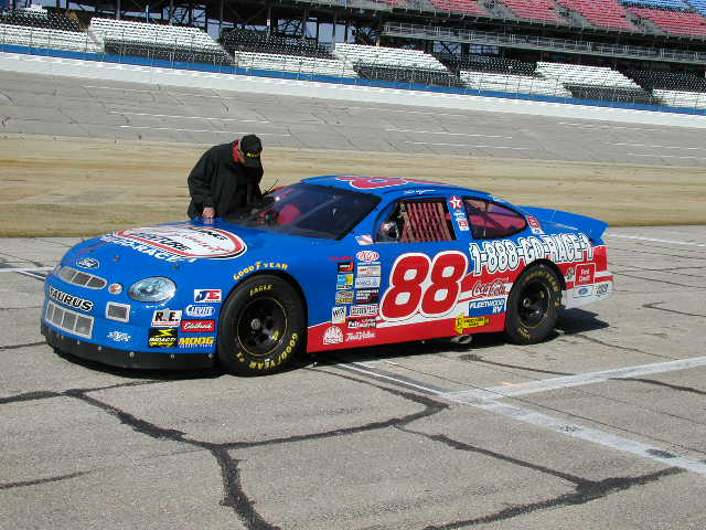
After slipping into a driving suit and helmet, I scramble through the window of the number 88 car, the same car that Dale Jarrett drove a couple of years ago in the “No Bull” competition. The safety crew straps me into the driver’s seat and I meet my instructor, Jarrod, who is strapped into the passenger seat next to me. He gives me the thumbs up sign and I give the car some gas and let out the clutch. We lurch ahead, the engine shoving me back in the seat as we speed down pit road and into the first turn. We accelerate through the first two turns and onto the backstretch and I am assaulted with a barrage of bellowing engine noise, g-forces, and wind blasting through the open windows.
I’m not a novice at this, I once drove a NASCAR car at Lowe’s Motor Speedway, at one of those follow-the-leader schools where you trail behind an instructor’s pace car, and passing and speed are tightly controlled. After my first lap at Talladega, the difference in that experience and this one is apparent. Instead of doggedly following an instructor-driven car around the track, I am able to go where I want, as fast as I want. At lap three I see one of my fellow drivers ahead. I blow by him like he’s standing still. Take that Earnhardt! I try drafting, passing, and side-by-side racing with the other drivers. My in-car instructor basically turns me loose to let her rip.
I’m having a blast—this is way more fun than any other driving experience. And then I see the flag man up in the starter box giving me the two fingers sign –“Two laps to go!” About five more miles to see how fast I can go. So I keep my foot to the floor all the way around the track, even through the turns. I feel my lap speeds picking up and the G-forces are tugging at me through the turns. The wall blurs by my right window and the bellow of 600 horses rings in my ears. We’re flying, the car bouncing around as even the slightest bump sends me sideways a few feet.
All too soon I see the checkered flag, my track time is up. I do a cool down on the backstretch and pull into the pits. I climb out the window and hit the ground on wobbly legs. I am told that my top speed was 181 miles per hour—faster than I’ve ever gone earthbound. I have only one regret--I didn’t have an extra $3495 lying around to do the 60 lap package.
(This article originally appeared in the Huntsville Times)
It sounded easy when I was sitting through my orientation session for the Dale Jarrett Racing Adventure but it’s not so easy when all you can see rushing toward you is what looks like a near-vertical bank of asphalt backed up by a very hard concrete wall. I force my foot to stay planted on the gas and my forearms tighten to a death grip on the thick steering wheel. No time to think now, my Ford Taurus tilts crazily as it bends into the turn and suddenly the sky is blue out my right window and the green grass infield is out my left—and I’m still on four wheels. The steep 33-degree banking has crazily tilted my Sprint Cup car nearly on its side—all this while I am hauling around the track at over 170 miles per hour.
Is this how Dale Jarrett does it? Must be, because his experience, the Dale Jarrett Racing Adventure, has tutored me on the proper line through the turns, the need to keep my foot planted on the gas pedal, and the no-wimps-allowed control required to guide this 3600-pound beast around the notorious banked tri-oval. The Adventure has been giving speed-starved Tony Stewart wannabe’s like me this on-track adrenaline rush for over six years and has expanded its program to include nine tracks around the country, with Talladega being the jewel of the nine sites. This is not a school for aspiring Sprint Cup champions; it’s an opportunity for the average racing fan to get off of the couch and participate in the thrill of manhandling an ornery piece of heavy American metal around the same track that the Sprint Cup regulars jockey around on Sunday afternoons.
For a gear-head like me, this is a fantasy fulfilled. Where else can you step off the street and, after an hour of classroom instruction, pound around the banking at Talladega at over 180 miles an hour? And the only thing limiting your fun time on the track is your wallet. There are options ranging from the six-lap Superspeedway Teaser ($395) all the way up to the 60-lap Championship Challenge ($3495).
I opt for a package called the Season Opener, which consists of 30 minutes or so of classroom driving instruction followed by ten laps on the track. The instruction takes place in a nondescript building in the Talladega infield. Dominating the view on all sides are the track’s monstrous banked turns. There’s only one way to describe the track: intimidating. I’m thinking maybe this wasn’t such a great idea.
The program’s emphasis is on track time, not on spending a lot of time listening to some instructor in a classroom. Since we are all squirming in our seats, barely able to contain our excitement, our instructor keeps the orientation mercifully short, mainly explaining the hand signals (faster, slower, left, right, stop) that we will receive from the in-car instructor who will be sitting in the passenger seat. One more step before we head for our race cars—a quick familiarization run around the track in a van. Our van driver points out two parallel lines running the length of the front stretch and into the first turn. “This is the line you’ll follow,” he says, “miss it and you’ll kiss the wall.” That’s when I started thinking about the hardness of concrete.
We pull onto pit road next to a pack of vividly painted cars, looking fast and mean just sitting still. Sitting low on fat tires with exhaust pipes as big as your arm sticking out from under the doors, it’s obvious that these are the real thing. They are in fact retired Sprint Cup cars, albeit a couple of years removed from the front lines of the Cup chase.
After slipping into a driving suit and helmet, I scramble through the window of the number 88 car, the same car that Dale Jarrett drove a couple of years ago in the “No Bull” competition. The safety crew straps me into the driver’s seat and I meet my instructor, Jarrod, who is strapped into the passenger seat next to me. He gives me the thumbs up sign and I give the car some gas and let out the clutch. We lurch ahead, the engine shoving me back in the seat as we speed down pit road and into the first turn. We accelerate through the first two turns and onto the backstretch and I am assaulted with a barrage of bellowing engine noise, g-forces, and wind blasting through the open windows.
I’m not a novice at this, I once drove a NASCAR car at Lowe’s Motor Speedway, at one of those follow-the-leader schools where you trail behind an instructor’s pace car, and passing and speed are tightly controlled. After my first lap at Talladega, the difference in that experience and this one is apparent. Instead of doggedly following an instructor-driven car around the track, I am able to go where I want, as fast as I want. At lap three I see one of my fellow drivers ahead. I blow by him like he’s standing still. Take that Earnhardt! I try drafting, passing, and side-by-side racing with the other drivers. My in-car instructor basically turns me loose to let her rip.
I’m having a blast—this is way more fun than any other driving experience. And then I see the flag man up in the starter box giving me the two fingers sign –“Two laps to go!” About five more miles to see how fast I can go. So I keep my foot to the floor all the way around the track, even through the turns. I feel my lap speeds picking up and the G-forces are tugging at me through the turns. The wall blurs by my right window and the bellow of 600 horses rings in my ears. We’re flying, the car bouncing around as even the slightest bump sends me sideways a few feet.
All too soon I see the checkered flag, my track time is up. I do a cool down on the backstretch and pull into the pits. I climb out the window and hit the ground on wobbly legs. I am told that my top speed was 181 miles per hour—faster than I’ve ever gone earthbound. I have only one regret--I didn’t have an extra $3495 lying around to do the 60 lap package.
(This article originally appeared in the Huntsville Times)
A River Runs Through Him
We met Harry at Shawnee Creek, under a cooling canopy of hickory and sycamore trees. It was getting late and we pointed our canoe toward the low sandbar that had formed where the narrow creek flowed into the swift running Current River. My longtime canoeing buddy Jim and I wanted to cook up a hot shoreside meal before paddling another hour downriver to a favorite campsite.
We saw Harry standing on the edge of the sandbar, hands clasped behind his back staring out over the Current’s sparkling riffles. The low sun filtered through the trees and silhouetted his stooped figure. Tiny embers of golden sunlight jetted from the dancing waters in front of him. I remembered my camera stashed away in a duffle bag.
Our paddles interrupted his reverie, but he was glad to see us. We could read it in his eyes. He introduced himself, asked how far we were paddling. He talked through one of those voice boxes, holding his hand to his throat to make sure the device worked. Normally we like to visit with these “river rats” who gravitate to the banks of running waters. We enjoy hearing their stories and swapping lies. But this evening we were in a hurry, needing to eat and make camp downstream before dark.
Harry had other ideas. He asked us how far we’d come, what we’d seen, where we were from. His eyes were deep green, a young man’s spark in an old man’s orbs. He told old man’s stories, full of reminisces and cherished weavings of warmly held memories. He’d lived his whole life on the banks of this river, in a small and cozy house high on a bluff. He saw the river every morning and every night. It never changed, looked just like this when he was a little boy, fishing for bass and catching crawdads. He used to swing on a thick rope, high out over the river and let go to fall splay-legged into the cool pool below. The old rope was still hanging on a thick limb nearby. It had been a good life.
Things weren’t going so good now. His wife had died last winter, just after the cancer ate up his larynx. The disease made him sick, and tired. He couldn’t drive to town much anymore. His kids had moved away and they sometimes came to visit, but they had their own lives. The grandkids didn’t care much for the river, they liked to sit in front of the TV. So he came down to the sandbar often, to see the river up close, to watch the water go by, a crystal ribbon of life, rushing by and gone.
Darkness was creeping over the river. Harry had held us captive and the sun had slipped away. We wanted to stay, so did Harry but he had to get home before dark—his eyesight wasn’t so good anymore—and we had a campsite to reach.
We pushed off and waved at Harry’s thin outline receding into the dusky shadows. He watched us drift downriver, out of his life. Dusk enveloped Harry, he melted into a wall of trees and water. I wondered how many things he’d watched drift out of his life, along the banks of this river.
(This article originally appeared in the Huntsville Times)
We saw Harry standing on the edge of the sandbar, hands clasped behind his back staring out over the Current’s sparkling riffles. The low sun filtered through the trees and silhouetted his stooped figure. Tiny embers of golden sunlight jetted from the dancing waters in front of him. I remembered my camera stashed away in a duffle bag.
Our paddles interrupted his reverie, but he was glad to see us. We could read it in his eyes. He introduced himself, asked how far we were paddling. He talked through one of those voice boxes, holding his hand to his throat to make sure the device worked. Normally we like to visit with these “river rats” who gravitate to the banks of running waters. We enjoy hearing their stories and swapping lies. But this evening we were in a hurry, needing to eat and make camp downstream before dark.
Harry had other ideas. He asked us how far we’d come, what we’d seen, where we were from. His eyes were deep green, a young man’s spark in an old man’s orbs. He told old man’s stories, full of reminisces and cherished weavings of warmly held memories. He’d lived his whole life on the banks of this river, in a small and cozy house high on a bluff. He saw the river every morning and every night. It never changed, looked just like this when he was a little boy, fishing for bass and catching crawdads. He used to swing on a thick rope, high out over the river and let go to fall splay-legged into the cool pool below. The old rope was still hanging on a thick limb nearby. It had been a good life.
Things weren’t going so good now. His wife had died last winter, just after the cancer ate up his larynx. The disease made him sick, and tired. He couldn’t drive to town much anymore. His kids had moved away and they sometimes came to visit, but they had their own lives. The grandkids didn’t care much for the river, they liked to sit in front of the TV. So he came down to the sandbar often, to see the river up close, to watch the water go by, a crystal ribbon of life, rushing by and gone.
Darkness was creeping over the river. Harry had held us captive and the sun had slipped away. We wanted to stay, so did Harry but he had to get home before dark—his eyesight wasn’t so good anymore—and we had a campsite to reach.
We pushed off and waved at Harry’s thin outline receding into the dusky shadows. He watched us drift downriver, out of his life. Dusk enveloped Harry, he melted into a wall of trees and water. I wondered how many things he’d watched drift out of his life, along the banks of this river.
(This article originally appeared in the Huntsville Times)
Wednesday, July 21, 2010
On and On
For one brief buoyant moment the ever-optimistic environmentalists held out hope that the general public would finally come to their senses and realize the awful price we pay as a society to drive our RVs and Hummers. As the magnitude of the BP oil spill in the Gulf of Mexico unfolded and TV screens were filled with pictures of pelicans fatally coated in viscous oil, pristine beaches awash in messy patches of sludge and turtles burned alive in oily waters, enviros figured that, surely, the public would finally grasp what we are losing by our blind continued reliance on oil.
Once again proving how foolish it is to ever think that Americans will give up their cozy lifestyles no matter the cost to the planet. Even in the face of this monumental catastrophe, our elected officials, ever seeking the easy and expedient way out, railed against anything that might possibly cause people to sacrifice or change their way of life in even the most miniscule way. Governor Bobby Jindal of Louisiana is the poster boy for this shameless disingenuousness. I’m sorry, but quit your bitching about the horrible effects of the oil spill on your state—hell, you’ve been an apologist to and a sycophant to the oil industry for years. This is what happens when you sleep with the devil. If you’re willing to take Big Oil’s money then don’t bitch about all that comes with it—the pollution, the dead birds, the closed fisheries.
It is beyond foolish to think that more than 20,000 wells can be drilled in the Gulf and that not one—not 1 in 20,000—will have some kind of mechanical or human or Act of God failure that will result in an adverse impact on the environment and the economy. If you believe offshore drilling is that infallible I have three words for you: You’re an idiot. And God knows, when profit and greed are in play—as they most surely were in this case—expediency and corner cutting make mistakes inevitable.
So I don’t want to hear Bobby Jindal-- or Tony Kennon, the Mayor of Orange Beach, Alabama who was actually standing on the city’s soiled beaches as he declared his continued support for offshore drilling--complaining about BP, the Coast Guard and the Obama Administration when they are and continue to be cheerleaders for the oil industry. In fact, I have a hard time having sympathy for all those coastal residents who cry about the terrible impact of the spill on their lives when in the next breath they say they still support offshore drilling.
OK, that’s your prerogative but if that’s the way you feel, suck it up and take it like a man when things go awry. Don’t come looking for shoulders to cry on when you still haven’t learned your lesson. You’ve already proven that you’re willing to sell your environment and your lifestyle to the oil industry. You consciously made that choice, now you expect us to feel sorry for you? You want oil wells in your backyard? You got ‘em. And everything that comes with them. Shut up.
And that’s why environmentalists are once again destined to be sorely disappointed. A year from now this whole fiasco will be yesterday’s news. Just like Haiti is now. Six months after the earthquake, public attention has shifted back to the usual schlock---Lindsay’s drunken escapades and Mel’s latest tirade—and the people of Haiti, living in tents and suffering are forgotten.
Same with the oil spill. Nothing will change—no climate legislation, no lasting offshore drilling moratorium, no energy bill. And a few years down the road another spill will stain our shores and cause a flurry of recrimination and brief but unfulfilled hope for effective energy and environmental policies. And on and on.
Once again proving how foolish it is to ever think that Americans will give up their cozy lifestyles no matter the cost to the planet. Even in the face of this monumental catastrophe, our elected officials, ever seeking the easy and expedient way out, railed against anything that might possibly cause people to sacrifice or change their way of life in even the most miniscule way. Governor Bobby Jindal of Louisiana is the poster boy for this shameless disingenuousness. I’m sorry, but quit your bitching about the horrible effects of the oil spill on your state—hell, you’ve been an apologist to and a sycophant to the oil industry for years. This is what happens when you sleep with the devil. If you’re willing to take Big Oil’s money then don’t bitch about all that comes with it—the pollution, the dead birds, the closed fisheries.
It is beyond foolish to think that more than 20,000 wells can be drilled in the Gulf and that not one—not 1 in 20,000—will have some kind of mechanical or human or Act of God failure that will result in an adverse impact on the environment and the economy. If you believe offshore drilling is that infallible I have three words for you: You’re an idiot. And God knows, when profit and greed are in play—as they most surely were in this case—expediency and corner cutting make mistakes inevitable.
So I don’t want to hear Bobby Jindal-- or Tony Kennon, the Mayor of Orange Beach, Alabama who was actually standing on the city’s soiled beaches as he declared his continued support for offshore drilling--complaining about BP, the Coast Guard and the Obama Administration when they are and continue to be cheerleaders for the oil industry. In fact, I have a hard time having sympathy for all those coastal residents who cry about the terrible impact of the spill on their lives when in the next breath they say they still support offshore drilling.
OK, that’s your prerogative but if that’s the way you feel, suck it up and take it like a man when things go awry. Don’t come looking for shoulders to cry on when you still haven’t learned your lesson. You’ve already proven that you’re willing to sell your environment and your lifestyle to the oil industry. You consciously made that choice, now you expect us to feel sorry for you? You want oil wells in your backyard? You got ‘em. And everything that comes with them. Shut up.
And that’s why environmentalists are once again destined to be sorely disappointed. A year from now this whole fiasco will be yesterday’s news. Just like Haiti is now. Six months after the earthquake, public attention has shifted back to the usual schlock---Lindsay’s drunken escapades and Mel’s latest tirade—and the people of Haiti, living in tents and suffering are forgotten.
Same with the oil spill. Nothing will change—no climate legislation, no lasting offshore drilling moratorium, no energy bill. And a few years down the road another spill will stain our shores and cause a flurry of recrimination and brief but unfulfilled hope for effective energy and environmental policies. And on and on.
Sunday, July 4, 2010
The BP Spill Hits Alabama Beaches
We trekked down to Fort Morgan Peninsula to see first hand if CNN’s dire reports from the beaches were media hype. Unfortunately, the reality is even worse than the televised reports. Alabama’s beaches are just beginning to suffer from the BP oil spill but even at this early stage—when the oil is just starting to trickle onto the white sands—the enormity of what is happening in the Gulf is sad and depressing.
Fort Morgan’s beaches are awash with tar balls; black, viscous invaders that range from pea size to grape size, some the size of poker chips. Periodically there are large patches of thick gooey oil, the size of a living room, ugly and smelly. The white sand is stained, caramel colored, up to the surf line and a lacey fringe of coffee-colored foam marks the apex of each incoming wave.
In the midst of the mess we stumble upon a disaster recovery crew, under contract to BP according to the workers. They are cleaning up tar balls on the beach. With the miles of beaches that are damaged, it seems like emptying a 55 gallon drum with a teaspoon—and yeah, I know, enough teaspoons will eventually empty the drum--but I am dumbfounded that rakes and garbage bags are our best response to this disaster. With all of America’s technology this is the best we can do? Seems like a remarkably Third World solution to a First World problem. And the next day the tide brings in more tar to cover the very area just cleaned.
The water itself is oily, mixed into a frothy emulsion by the pounding surf from Hurricane Alex. A few orange booms bob in the surf, each incoming wave barely impeded in its advance as it washes over the top of the boom. I reach in the surf and pull back a slippery, oil-stained hand. Pelicans are diving into the water offshore and I wonder how often they can make those dives before their feathers are impregnated with petroleum, their gullets full of poison. How much oil can they consume before it’s too much? The oil here is not the thick and gooey mess that accumulates in teh marshes so these birds will not show up in one of the rehab facilities. They'll probably slowly ingest enough oil that eventually they sicken and die somewhere out at sea or in the dunes, forgotten and uncounted.
That beautiful comforting fragrance of the ocean, a mix of salt air and fish, is masked by a strong industrial odor—the kind that makes you wrinkle your nose when you drive by a refinery.
The wildlife will suffer, no doubt about it. The sandpipers and willets that normally scurry before the incoming surf are noticeably absent. We don’t see any dolphins, unusual enough that we remark on it, we almost always see them swimming and hunting near offshore. Sea turtles will have to swim through the mess to lay their eggs on the beach and then what? The plan is to remove the eggs to a hatchery on the Atlantic coast, a desperate measure with an unknown outcome.
A disaster, no doubt about it. But how bad? From my perspective the efforts of BP seem more of a PR effort than anything that is really having any effect. I can’t see anything other than a massive die off of marine creatures, the base of the food chain that feeds the birds, turtles, dolphins and fish going first, followed by the rest.
That beautiful comforting fragrance of the ocean, a mix of salt air and fish, is masked by a strong industrial odor—the kind that makes you wrinkle your nose when you drive by a refinery.
The wildlife will suffer, no doubt about it. The sandpipers and willets that normally scurry before the incoming surf are noticeably absent. We don’t see any dolphins, unusual enough that we remark on it, we almost always see them swimming and hunting near offshore. Sea turtles will have to swim through the mess to lay their eggs on the beach and then what? The plan is to remove the eggs to a hatchery on the Atlantic coast, a desperate measure with an unknown outcome.
A disaster, no doubt about it. But how bad? From my perspective the efforts of BP seem more of a PR effort than anything that is really having any effect. I can’t see anything other than a massive die off of marine creatures, the base of the food chain that feeds the birds, turtles, dolphins and fish going first, followed by the rest.
Friday, April 30, 2010
Guatemala and Hurricane Stan
We spent ten days in Guatemala, never saw the sun. We arrived in country the same day as Hurricane Stan and experienced the country through a wet prism of torrential rain, flooding, landslides and cold weather (yes, you can see your breath in Central America). We planned for a week of mountain climbing, kayaking, biking and hiking but Stan had different ideas.
We stayed in the historic town of Antigua in Guatemala’s central highlands. Antigua is a UNESCO World Heritage site and deservedly so. Its colonial churches of Spanish Baroque architecture are backdropped against a ring of volcanic mountains, picturesque to the extreme.
I caught a plane to the Yucatan Peninsula to see Tikal, Ed hired a guide and took on the mountain. My idea was better. Tikal is amazing, one of the largest archaeological sites of pre-Columbian Maya civilization. It is a huge complex of ruins rising spectacularly out of the jungle. I enjoyed two days of DRY hiking and exploration.
We stayed in the historic town of Antigua in Guatemala’s central highlands. Antigua is a UNESCO World Heritage site and deservedly so. Its colonial churches of Spanish Baroque architecture are backdropped against a ring of volcanic mountains, picturesque to the extreme.
We found our home in a small bar on Norte Calle, just south of the St Madrid Cathedral. The bar buzzed with a lively crowd of Irish, English, German and New Zealand expats and tourists and the Australian bartender was quick with a joke and a beer and we found ourselves returning nightly for a dry place for conversation and beers .
Our days were wet but that didn’t keep us from enjoying the country. We picked up bikes and pedaled along the Pan-American Highway which snakes through the highlands and the lush jungles of Central America. In Guatemala, as in the rest of Central America, it is the main artery for commerce and travel but we found it surprisingly deserted the day we rode it. That’s what biblical flooding and blinding rainstorms will do to traffic. The weather and the seemingly endless uphill tarmac were brutal and we struggled up the highway. Last night’s beer didn’t help.
But we pressed on, pedaling through the mists and fog until we happened on an open roadside pavilion. Exhausted and in need of a break we stopped and were greeted by a delightful Guatemalan family. A bevy of little kids gathered around us, undoubtedly wondering what these crazy Gringos were doing riding bikes in the rain. The kids were happy and laughing and they recharged our batteries. That, and the fact that we had reached the apex of the highway over the mountain and it was all downhill from now on, made for a great finish to a grueling ride. We coasted downhill for miles, descending out of the clouds to clear views of lovely Lake Atitlan, situated in a caldera among three volcanos. The lake was blue and glassy, a pleasant change from what we had been through so far. We cruised into the village of Panajachel on the shores of the lake.
Panajachel was in the midst of their annual village festival, complete with greased pole climbs, dancers in native costume and a thriving marketplace and we spent the afternoon enjoying the festivities before catching a launcha across the lake to a guesthouse perched gloriously on the lakeside cliffs. After a hot meal we drank wine and shared a communal hot tub overlooking the lake with other guests.
The next day we set out at dawn, choosing to hike the lake perimeter back into Panajachel. Rain drenched us again, and we trekked through villages and fields of fifteen foot high corn along a barely discernible footpath through the jungle. We hiked quietly through a village adorned with Anti-American graffiti as we practiced our fake Aussie accents. We encountered native children who scampered away in panic at the sight of us in their midst. I don’t think they had ever seen Gringos before. This was definitely off the beaten path. We stumbled into Panajachel and caught a truck ride back to Antigua just as another torrential storm set in. The road became a dangerous quagmire and we dodged desk-sized boulders and muddy landslides ripping down the mountainsides and across the road.
The unremitting bad weather changed our plans. We were to take a kayak trip through the coastal mangroves but the flooding made that impossible. We retreated to Antigua and reassessed our itinerary. We had planned to climb Acatenango, a 13,045 foot volcanic peak but I opted out. My friend Ed stuck to the plan.
Ed spent two days huddled with his guide, rain, and fog in a climbing hut on the side of Acatenango. He never saw the peak, never even made it above tree line.
We left Guatemala as we came in, wet. With the exception of my two days at Tikal, we were rained on—heavily—daily. But we loved the country, the people and the experiences. Not a typical tourist trip, exactly what we wanted.
Thursday, April 29, 2010
Climbing Mt Shasta
There are easy ways and hard ways to climb Mount Shasta. Never ones to miss out on a chance to up the ante, my friend Ed and I opted for the hard way. Our mistake.
North California’s Mount Shasta, at 14,179 feet, is the fifth highest peak in California. The mountain’s massive peak dominates the surrounding countryside and we could see it looming in our windshield from 100 miles away as we drove into the Cascades. It was imposing, its broad slopes glowing in the September sun.

Shasta is a popular destination for climbers and on a summer weekend 200 people or more may attempt the summit. By far the most popular routes are on the south and west slopes. Over 80% of climbers attempt these two approaches, with most of them taking the Avalanche Gulch route. These approaches are non-technical climbs, just requiring long and steady slogs up Shasta’s demanding slopes.
The north and east slopes are more challenging and are dominated by four large glaciers that complicate the climb, demanding advanced climbing skills and the ability to use ropes, ice axes and crampons. We elected to climb Shasta from the northeast side, across the long snowfields of the Hotlum and Bolam glaciers, laced with steep snow, ice and loose talus. By September, the snowfields were crusty and streaked with crevasses, further complicating our summit attempt. This approach was what we wanted, something far more challenging than the traditional south and west slopes.
We stood with Tony, our British mountain guide, in the valley below and surveyed the mountain, tracing our route up the alpine meadows, across the glaciers and to the summit. It looked intimidating. We would accomplish the trip in two days, making an overnight base camp at about 10,500 feet. This would give us time to acclimate to the altitude. We would make camp before dark, get a short night’s sleep and then strike out the last 3600 feet to the summit before sunrise the next day.
Our climb began uneventfully in a high alpine meadow near the base of the mountain. We spent the day slogging relentlessly uphill, huffing up unrelenting slopes, the sunny day perfect for a warm and pleasant climb. We climbed all morning and all afternoon, the green meadows gradually turning to rocky talus, then to boulder fields, then to snowfields and finally to icy glacial sheets laced with rotten ice and wide crevasses. We made base camp at 4 PM and immediately grabbed crampons and axes and set out across the glacier to get the feel of the ice before attempting the summit the next morning.
Ominously, the skies clouded up as we traipsed back to base camp and we remarked on the deteriorating conditions while we made hot tea and dinner. We had no idea what the mountain was about to hand us. We awoke a couple of hours later to the sound of our tent flapping furiously in the wind. A full scale gale had blown in and was whipping up the mountain, bringing with it cold temperatures and a furious blizzard. Peering out into the darkness we could barely see our guide’s tent a mere twenty feet away. The storm raged all night, the temperature dipping precipitously and the snow bringing near whiteout conditions.
When we hopped out of our tents at 3AM conditions were bleak for a summit attempt but we decided to give it a go anyway. The climbing was slow and miserable, fog and snow limiting our ability to pick our path up the mountain. The slopes were becoming even icier and we quickly fell behind schedule. The three of us were roped together as we struggled up the glacier and we stopped frequently to recon our route. We were slowly running out of steam, cold and unable to see much more than thirty feet.
Then I heard something falling above me and jerked my head upward to see Tony sliding down the mountain towards us. I braced against the ice face, anchoring my crampons and axe in the ice. We were roped together and being jerked from the side of the mountain by a falling body would be a disaster. I watched in horror as he skated down the slope and suddenly—miraculously—he slid onto a narrow shelf, no more than two feet wide but enough to break his fall. We rushed over to see if he was okay and we discovered that the shelf that had broken his fall had also wrenched his knee. That injury ended our summit attempt.
I was crushed but the approach we had elected was a difficult one—our guide had only successfully led two of eight teams to the top by this route. And the two days on the mountain were exciting and beautiful, the views above the clouds from base camp were breathtaking. We didn’t reach the summit but it’s not always the summit that you remember anyway.
North California’s Mount Shasta, at 14,179 feet, is the fifth highest peak in California. The mountain’s massive peak dominates the surrounding countryside and we could see it looming in our windshield from 100 miles away as we drove into the Cascades. It was imposing, its broad slopes glowing in the September sun.

Shasta is a popular destination for climbers and on a summer weekend 200 people or more may attempt the summit. By far the most popular routes are on the south and west slopes. Over 80% of climbers attempt these two approaches, with most of them taking the Avalanche Gulch route. These approaches are non-technical climbs, just requiring long and steady slogs up Shasta’s demanding slopes.
The north and east slopes are more challenging and are dominated by four large glaciers that complicate the climb, demanding advanced climbing skills and the ability to use ropes, ice axes and crampons. We elected to climb Shasta from the northeast side, across the long snowfields of the Hotlum and Bolam glaciers, laced with steep snow, ice and loose talus. By September, the snowfields were crusty and streaked with crevasses, further complicating our summit attempt. This approach was what we wanted, something far more challenging than the traditional south and west slopes.
We stood with Tony, our British mountain guide, in the valley below and surveyed the mountain, tracing our route up the alpine meadows, across the glaciers and to the summit. It looked intimidating. We would accomplish the trip in two days, making an overnight base camp at about 10,500 feet. This would give us time to acclimate to the altitude. We would make camp before dark, get a short night’s sleep and then strike out the last 3600 feet to the summit before sunrise the next day.
Our climb began uneventfully in a high alpine meadow near the base of the mountain. We spent the day slogging relentlessly uphill, huffing up unrelenting slopes, the sunny day perfect for a warm and pleasant climb. We climbed all morning and all afternoon, the green meadows gradually turning to rocky talus, then to boulder fields, then to snowfields and finally to icy glacial sheets laced with rotten ice and wide crevasses. We made base camp at 4 PM and immediately grabbed crampons and axes and set out across the glacier to get the feel of the ice before attempting the summit the next morning.
Ominously, the skies clouded up as we traipsed back to base camp and we remarked on the deteriorating conditions while we made hot tea and dinner. We had no idea what the mountain was about to hand us. We awoke a couple of hours later to the sound of our tent flapping furiously in the wind. A full scale gale had blown in and was whipping up the mountain, bringing with it cold temperatures and a furious blizzard. Peering out into the darkness we could barely see our guide’s tent a mere twenty feet away. The storm raged all night, the temperature dipping precipitously and the snow bringing near whiteout conditions.
When we hopped out of our tents at 3AM conditions were bleak for a summit attempt but we decided to give it a go anyway. The climbing was slow and miserable, fog and snow limiting our ability to pick our path up the mountain. The slopes were becoming even icier and we quickly fell behind schedule. The three of us were roped together as we struggled up the glacier and we stopped frequently to recon our route. We were slowly running out of steam, cold and unable to see much more than thirty feet.
Then I heard something falling above me and jerked my head upward to see Tony sliding down the mountain towards us. I braced against the ice face, anchoring my crampons and axe in the ice. We were roped together and being jerked from the side of the mountain by a falling body would be a disaster. I watched in horror as he skated down the slope and suddenly—miraculously—he slid onto a narrow shelf, no more than two feet wide but enough to break his fall. We rushed over to see if he was okay and we discovered that the shelf that had broken his fall had also wrenched his knee. That injury ended our summit attempt.
I was crushed but the approach we had elected was a difficult one—our guide had only successfully led two of eight teams to the top by this route. And the two days on the mountain were exciting and beautiful, the views above the clouds from base camp were breathtaking. We didn’t reach the summit but it’s not always the summit that you remember anyway.
Subscribe to:
Posts (Atom)